Welcome to EcoTech

Mapping Hazard Trees for a Safer Environment

Get Started

EcoTech


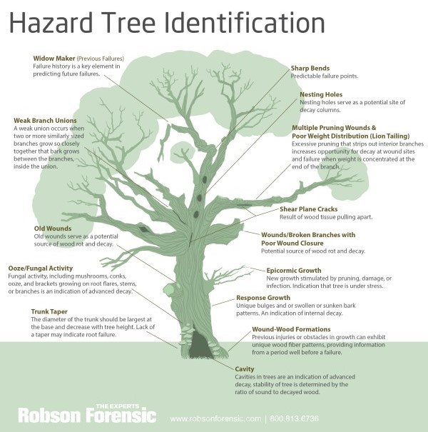
Hazard mapping for trees: Our core service will help map the location and condition of trees in order to identify which ones are hazardous. It provides detailed reportages on tree health, including such threats as decay, weak limbs, or structural instability.


EcoTech Hazard Mapping - Tree for a Safe Environment.


One mission that we have here at EcoTech Hazard Mapping is creating a safer, more sustainable environment for communities all over the world through the identification and management of potential environmental hazards such as those related to trees. Trees are necessary for our ecosystem; they provide us with oxygen, fight climate change, and support biodiversity. However, in some cases, trees can also be dangerous to human safety due to their condition, location, or potential to cause damage during storms or natural disasters. Our goal is to mitigate these hazards so that trees contribute positively to our environment rather than becoming threats.

Tree Image

Why Do We Build This Application


The requirement to consider environmental safety in urban and rural settings created the concept of EcoTech Hazard Mapping. Undeniably, trees have their benefits, but extreme weather events are becoming more frequent, and combined with aging urban infrastructure, the threat that trees pose to people and property is now more frequent than ever.


EcoTech Hazard Mapping provides real-time insights with hazard predictions on various forms of tree-related risks. We, with this app, wish to provide a solution that should empower local authorities, urban planners, homeowners, and environmental activists who can easily identify hazardous trees near them.